|
|
|
APRS/CE 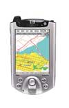
APRS/CE allows you to display maps showing the real-time location of both your station (if GPS equipped) and various other APRS stations on your Windows CE device. It also allows you to do two-way, real-time text messaging to stations. Try it for free! Key Features APRS/CE is a version of APRS (Automatic Position Reporting System) designed to run on Windows CE-based devices (also known as Windows Mobile). APRS is designed to provide mapping of stations, two-way messaging, and is great for any situation that requires real-time, tactical data. Examples would be: plotting of staff during a road race, regional disaster emergency communication, tracking and recovery of weather balloons, and many others. APRS/CE can operate over a wide variety of communications media, including both packet radio and the Internet. It can accept position data from nearly any NMEA-compatible GPS, including wireless Bluetooth GPS devices (provided your Windows Mobile device is Bluetooth-enabled.) APRS/CE can display maps designed for both Win/MacAPRS and PocketAPRS maps. With the new map editor, MapEd, you can import U.S. Census TIGER/Line data, available on CD or DVD from us, and create your own detailed maps for anywhere in the United States and its territories. APRS/CE is shareware. You can download it and use it as much as you like. It is fully functional, but it will not save your settings until you register the software, which is free. MapEd 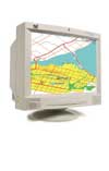
MapEd allows you to load Win/MacAPRS maps and PocketAPRS maps, and import U.S. Census Bureau TIGER/Line map data. Once loaded or imported, you can alter and add lines, filled regions, labels to each map, and you can export the map data for use with APRS/CE. Key Features MapEd is our latest product - a map editor for use with our APRS/CE and other APRS programs, such as Win/MacAPRS. MapEd allows you to load maps in Win/MacAPRS format or PocketAPRS format. Once loaded, each line, filled-in area, and label can be moved, changed, or deleted. New lines, filled-in areas, and labels can be added anywhere as desired. This will allow people to add custom routes to maps, for marathons, bike races, parades, etc. Locations of first aid stations, rest areas, and more can also be placed on a map. Once the map is as desired, MapEd can export the map in Win/MacAPRS format and PocketAPRS format for use with APRS/CE, Win/MacAPRS, and other APRS programs. |